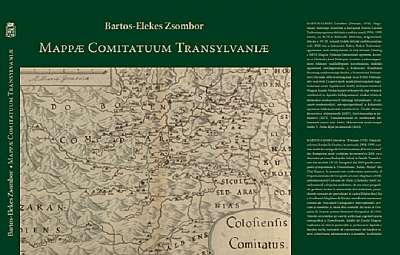
Mappae Comitatuum Transylvaniae
Descriere
Editie bilingva maghiară, română și engleză .HUN:A budapesti Egyetemi Könyvtár kiemelkedő értéke Hevenesi Gábor (1656–1715) jezsuita tudós gyűjteménye. E gyűjtemény 91. Kötete a 17. század végi, Habsburg-fennhatóság alá került Magyarország és Erdély vármegyéinek, székeinek és vidékeinek kéziratos térképeit tartalmazza. Az egyetlen példányban ismert munkának a szerzői ismeretlenek, nincs se keltezése, se valódi címe (Mappæ Comitatuum Regni Hungariæ névvel szokás hivatkozni rá). Az oszmán fennhatóság alóli felszabaduláskor készült térképsorozat jelentős: az erdélyi rész sokkal részletesebb a korábbi térképeknél; a Kárpát-medence első megyetérképei ezek, sőt Erdélyben a vármegyei–széki rendszer dualizmuskori felszámolásáig ez az egyetlen megyetérkép-sorozat. Jelen kötet elsőként teszi közzé a 18 erdélyi (és partiumi) térképlapot nyomtatott formában. A kiadvány részletes – magyar nyelvű, románra és angolra is lefordított – tanulmányt tartalmaz a térképek szerkezetéről és tartalmáról, továbbá készítésük hátteréről és környezetéről. A több mint ezer ábrázolt település, igazgatási egység, folyó és egyéb földrajzi részlet neveit névmutató gyűjti össze, amelyben azonosításukat a mai román, magyar és német névváltozataik segítik.RO:Una din comorile remarcabile care se găsesc în Biblioteca Universitară din Budapesta este colecția savantului iezuit Gábor Hevenesi (1656–1715). Al 91-lea volum din colecție cuprinde hărți manuscrise ale comitatelor, scaunelor și districtelor Ungariei și Transilvaniei de la sfârșitul secolului al 17-lea, după ce aceste teritorii au ajuns sub dominație habsburgică. Autorii nu au fost identificați, iar lucrarea este cunoscută într-un singur exemplar, nedatat și fără un titlu propriu-zis (referința uzuală este Mappæ Comitatuum Regni Hungariæ). Seria de hărți realizată după eliberarea de sub ocupația otomană are o însemnătate deosebită. Părțile transilvănene sunt reprezentate mult mai exact în comparație cu hărțile anterioare. Seria cuprinde primele hărți ale comitatelor din Bazinul Carpatic. Mai mult, în privința Transilvaniei aceasta este singura serie de hărți ale comitatelor și scaunelor tradiționale, care au funcționat până la înființarea statului dualist austro-ungar în 1867. În volumul de față sunt publicate pentru prima dată cele 18 foi de hartă care acoperă Transilvania, inclusiv Partiumul. Acesta mai cuprinde un studiu detaliat privitor la structura și conținutul hărților și condițiile realizării lor (în limba maghiară, tradus în limbile română şi engleză). Cele peste o mie de localități, unități administrative, râuri și alte elemente geografice care apar pe hărți sunt repertoriate într-un indice de nume. Ele pot fi identificate ușor datorită denumirilor actuale în limbile română, maghiară și germană.EN:The collection of the Jesuit scholar, Gábor Hevenesi (1656–1715) is considered a treasure of ELTE University Library (Budapest). The collection’s 91st volume contains manuscript county maps of the comitats, seats and districts of Hungary and Transylvania under Habsburg rule dating from the end of the 17th century. Only one copy of the work exists, which was compiled by unknown authors. It is undated and has no title (Mappæ Comitatuum Regni Hungariæ – this is how it is referenced in the library’s catalogue). The map series is significant as it presents the first county maps of the Carpathian Basin newly liberated from Ottoman rule. The Transylvanian part is much more detailed than earlier maps. Moreover, it constituted the only series of county maps in Transylvania until the traditional system of counties (comitats, seats and districts) was abolished during the dual monarchy of Austria-Hungary. The present volume publishes for the first time the 18 map sheets of Transylvania (and Partium). It contains a detailed study, written in Hungarian and translated into Romanian and English, of the structure and content of the maps and about the background and setting of their elaboration. Over a thousand settlements, administrative units, rivers, and other geographical features are collected into an index that contains their names along with their current Romanian, Hungarian and German name versions, which help their identification.
